The
Natural Origins of Scandinavia
by Bob Brooke
  Far
back in geologic times the "North" lay buried under the great
ice sheet. Slowly the frozen mass receded under the warmth of the sun.
The dynamic of geology asserted itself and the land rose, released of
its crushing burden. The Baltic Sea took shape as an inland lake in the
heart of Fenn-Scandia, the land mass comprising what’s now Finland,
Denmark, and the Scandinavian Peninsula. Far
back in geologic times the "North" lay buried under the great
ice sheet. Slowly the frozen mass receded under the warmth of the sun.
The dynamic of geology asserted itself and the land rose, released of
its crushing burden. The Baltic Sea took shape as an inland lake in the
heart of Fenn-Scandia, the land mass comprising what’s now Finland,
Denmark, and the Scandinavian Peninsula.
The
Baltic then rose higher and at last broke through a channel to reach the
North Sea, forming Oresund--the narrow sound between Denmark and Sweden.
The Danish lands were separated from the Scandinavian Peninsula, and the
waters of the Baltic made contact with the Atlantic. Boats could then
traverse the Baltic and sail out to the British Isles, to Iceland and
Greenland and Vinland. The Baltic provided pathways for travel and
commerce and nurturing a common culture.
The
barriers weren’t the sea but the vast forests and swamps which lay
between Finland and the inhabited parts of Russia. High mountains,
marshes, and broad barrens were what man could not cross. Thus isolated
from the East, Fenno-Scandia aligned itself and with the culture of the
West. The region was and remains a natural area of common culture, its
entire history intricately intertwined. The islands in the Atlantic,
separated by greater distances, still lay within easy reach of Viking
seamen and have borne the stamp of Scandinavian culture for over a
thousand years.
On the
globe, it seems hard to imagine an active modern society with large
towns prospering in latitudes more northerly than Labrador, with some of
the land above the Arctic Circle. The answer lies with the Atlantic
Ocean. Aided by winds from the west, it keeps the Scandinavian peninsula
warmed and watered. The Gulf Stream gives an added touch. But it’s the
whole breadth of salt water that modifies the winds, creates the
temperate marine climate, and makes the lands to the east livable. To
the west of the Atlantic, Labrador suffers under cold winds blowing off
the northern plains.
The
town of Tromso in northern Norway, located above latitude 69 degrees
North, has a winter temperature averaging about 37 degrees Fahrenheit
and a summer average just above 50 degrees. Spring flowers bloom in
February. The mountain backbone of the Scandinavian Peninsula blocks off
some of this ocean warmth, but never all of it. Even the west coast of
Finland feels something of the moderating influences from the west,
though by the time the winter breezes reach Finland's eastern border
they’ve lost their delicacy, and a northern "continental"
climate prevails.
Generally
Scandinavia has a stern, but not capricious climate. Hurricanes and
sizzling heat and earthquakes are unknown, floods and drought rare.
Moderation seems to be a habit of Mother Nature, though there are
exceptions.
Summer
in these northern lands brings days which linger through long twilight
far into the night. In the northernmost parts, for weeks before and
after the summer solstice one may see the sun which never sets but
merely glides low to the horizon and rises again. This is the
compensation for the long nights of darkness in the winter, and helps to
explain the sun worship in ancient ritual and on modern beaches.
The
warmth, the sun, the moisture dropped in frequent rains from the western
winds, make crops grow quickly where the soil is good. Yet the glacial
terrain of Finland and the Scandinavian Peninsula often leaves only
small patches of arable land, sometimes in inner valleys like
Gudbrandsdal in Norway or in strips between water and rock in the
western fjords, sometimes along quiet river mouths in northern Sweden,
or in clearings in Finland's forests. The ice sheets scraped off the
earlier topsoil, and the present thin covering is geologically recent,
lying on top of rocks 300 million years old.
Iceland
has vast stretches of barren land, and Greenland is only a name given by
Eric the Red, that early genius of real estate promotion. Greenland's
real claim to fame is her "icy mountains," one of the
determining forces in the climate of the world. The major food-producing
area of Scandinavia is in southern Sweden and in the fertile fields of
Denmark on the sedimentary rock plains. Great contrasts exist between
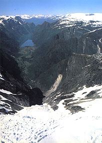
the grandeur of the western Norwegian fjords, with their perpendicular
walls, and the green shores of the Danish islands creeping out of the
sea.
In
Scandinavia sea and land exist together, complement each other. Man
lives on the land but draws sustenance from the sea and makes it serve
his needs. The sea isn’t only his highway of commerce, his connective
link within Scandinavia and with the lands which lie beyond. It’s also
his most dependable source of nourishment. "Norway has plenty of
food-but it's all fish" is exaggeration based on fact. The
fishermen of the Lofoten Islands and of the whole long coast, like the
fishermen of Iceland who provide that country's most important export,
attest the importance of the sea.
Ships
carry pulp, paper, and prefabricated houses to the markets of the world
through the Baltic Sea. It’s because the Baltic flowed to the west and
opened a sea route through the Danish Sound (Oresund) that Finland
maintains an active trade with the United States, 4,000 miles away, and
it’s the North Sea which makes Britain the best customer for Danish
butter and eggs.
The
coast lines of the Scandinavian countries are long and usable. Harbors
overflow with as many boats as the streets of Copenhagen do with
bicycles. When the Vikings began to build streamlined seagoing ships in
the 9th and 10th centuries, they were simply learning how to use the
natural advantages of their harbors. The fjords led to the ocean, and
the ocean continued to the lands beyond. It’s no accident that these
northern countries are leaders in seamanship and that Norway has one of
the largest merchant fleets of the world.
< Back
to Article Index |

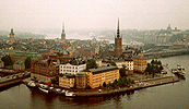
 Clustered
around the head of the 68-mile-long Oslofjord, Oslo is probably the most
spacious city in the world. Its 175-square-mile metropolitan area
consists of over 75 percent forests and five percent water. Its fine
deep harbor, Pipervika, stretches into the heart of the city and from it
leave ferries to Denmark and Germany.
Clustered
around the head of the 68-mile-long Oslofjord, Oslo is probably the most
spacious city in the world. Its 175-square-mile metropolitan area
consists of over 75 percent forests and five percent water. Its fine
deep harbor, Pipervika, stretches into the heart of the city and from it
leave ferries to Denmark and Germany.
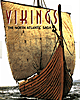 In
the early Middle Ages, driven by famine at home and the promise of
wealth to be had in other lands, the Vikings set out from Scandinavia to
conquer parts of England, Ireland, France, Russia, and even Turkey.
Bolstered by their successes, the Vikings pushed westward, eventually
crossing the North Atlantic and founding settlements in Iceland,
Greenland, and Newfoundland in Canada.
In
the early Middle Ages, driven by famine at home and the promise of
wealth to be had in other lands, the Vikings set out from Scandinavia to
conquer parts of England, Ireland, France, Russia, and even Turkey.
Bolstered by their successes, the Vikings pushed westward, eventually
crossing the North Atlantic and founding settlements in Iceland,
Greenland, and Newfoundland in Canada.